Historic Resources ➤ Farms ➤ Westfall Property Land and Soil History
The Buckland Farmstead
“The base of the land called the Buckland Farmstead was created at the end of the Paleozoic Era (Era of Ancient Life), a time period from 543 to 245 million years ago. The Genesee region emerged from the retreating sea waters. A deep covering of rock strata had been slowly built up, layer upon layer, over the igneous or volcanic rock base.”
– From “Rochester the Water-Power City 1812-1854” page 3, by Blake McKelvey

250,000 YBP*
The LAND called Buckland Farmstead:
Rock Base Formed
The one & three quarter inch long, Phacops rana trilobite was found by Leo Dodd on the shores of Lake Erie near Buffalo New York, imbedded in stone. The Paleozoic Era supported life that was swimming and crawling in the warm, shallow Paleozoic Oceans that covered the continents as we know them today. A time when life on Earth was in the beginnings. This little fellow may have swam in the waters off Westfall Road and may have visited Brighton before the Bucklands arrived. Phacops Rana is found both in the northeastern US and in Morocco, a country in North Africa. This can be explained by the fact that North America was attached to the African plate during the Devonian.
* YBP = Years Before Present

12,000 YBP
The LAND called Buckland Farmstead: Uncovered
The land called Buckland Farmstead was covered with ice till 12,000 years ago when the ice sheet began to melt. Slowly as the mile high ice receded north, revealing a new fresh soil, life moved on to the land. Climate warmed, plant life took hold and animal life invaded Brighton. Eventually on gaining enough richness to sustain human life our ancient ancestors arrived to live, hunt, farm and create communities. The Herman Fairchild drawn map (1909) illustrates the ice movement and the uncovering of the land in Brighton. It shows the maximum extent of the glacier during the latest (Wisconsin) glacial epoch titled … “Stage #1 in the Waning of The Ice Sheet in New York State.”**
Note: During the Wisconsin Glaciation, two extensive ice sheets occurred in North America: the Laurentide Ice Sheet to the east which covered much of Canada and the northern U.S. east of the Rocky Mountains, and the Cordilleran Ice Sheet to the west. Land and life resumed with the wasting of the Wisconsin glaciation that had covered the region for a large part of the previous 100,000 years.
From: “The Great Meadow – Farmers & The Land in Colonial Concord” by Brian Donahue page 27

Glacial History
This map, also drawn by Herman L. Fairchild in 1909, shows the extent of the glacier as it exited Brighton in the (Wisconsin) glacial epoch titled … “Stage #13 in the Waning of The Ice Sheet in New York State.”**
Glacial History: During the Pleistocene Epoch (1.8 million to ~10,000 years ago), numerous “ice ages” affected the Northern hemisphere. The last glacial event called the Wisconsinan Stage was at its maximum extent 19,000 to 22,000 years ago and covered nearly all of New York State. The Pinnacle Hills Moraine formed when the melting edge of the glacier retreated north from the Finger Lakes region then readvanced south to a position that is now the north slope of the Pinnacle hills Moraine. When this occurred the rock debris in the ice, ranging from fine clay, silt and sand to boulders was dumped at the melting edge. This material can be found today on the Buckland Farm on Westfall Road.

“Once the ice departed, the creation of soil began. If the ice had simply evaporated, subliming into thin air, virtually the entire Concord landscape would have been left covered with nothing but till. But of course the ice melted, so in many places the land was exposed to torrents of liberated water, which deposited silt, sand and gravel along melt water streams and beneath postglacial lakes.”**
From: “The Great Meadow -Farmers & The Land in Colonial Concord” by Brian Donahue, page 27
1,000 YBP
The LAND called Buckland Farmstead:
Inhabited by Native Americans
The land called Buckland Farmstead was farmed in an ancient manner by an ever increasing number of native hunters. Our knowledge of the of the Seneca Indians who were able to live on this land to 1800AD is well documented. The scraper tool found on this property in 2003 (shown in our farmland artifact collection) grants evidence to their existence on this property as the early farmers. “Native Americans are no longer dismissed for failing to improve the land. They are credited with maintaining ecologically sustainable ways of life over millennia thanks to their deep familiarity and spiritual closeness with the environment, to a cultural ecology that was imbedded in intact natural systems, and to the small population and limited material wants that marked their premarket economy.”**
**text from: The Great Meadow by Brian Donahue, p. 20-21
“The League of the Iroquois developed a rare spirit and a type of racial pride. Far from being a nomadic people who wandered hither and yon, the Iroquois had established villages and towns. Their religion taught the need of a thankful heart and of expressing gratitude in a practical way. They believed that the soil no less than the air belonged to all mankind and the land could no more be sold than the lakes or clouds. Only the right of occupancy could be a matter of question. The common necessities of life were construed as common rights to be shared by all.”***
***From: The Sullivan-Clinton Campaign by Arthur C. Parker, p. 47, Vol. VIII – The Rochester Historical Society
200 YBP
The LAND called Buckland Farmstead:
Governed by New York State:
The land called Buckland Farmstead gained legal status with the definition of New York State in the early nineteenth century. “Thus it was on a retarded frontier, surrounded by deep forests, penetrated only by rough roads and hazardous highways, that Rochester Village was born in 1812″** Our neighbors from surrounding states were beginning to migrate north and west to take advantage of the virgin land for farming. New England Pioneers first came to the Genesee Country on foot through the wilds, and some with ox-teams and covered wagons. The Bucklands arrived from Green Mountains of Vermont, Gideon Cobb from Pawlet, Rutland, Vermont, Oliver Culver born in East Windsor, Connecticut, Harvey Little born in Williamsburg, Massachusetts and Colonel Nathaniel Rochester from Virginia.
**from “Rochester the Water-Power City 1812-1854” page viii by Blake McKelvey.
“The end of the Revolutionary War marked the beginning of land investment in Western New York State. Nathaniel Gorham and Oliver Phelps bought from the Commonwealth of Massachusetts the land bounded on the west by the Genesee River, north by Lake Ontario, east by Seneca lake and south by the Pennsylvania border. The surveyors laid out 102 towns, each of which was six mile square. Township Number Thirteen of Range Seven encompassed what is now Brighton, which was approximately 18,900 acres.”***
*** From “A History of The Browncroft Area”.page 27
1930
The LAND called Buckland Farmstead:
Monroe County Aerial Map
The land called Buckland Farmstead is pictured by an aerial photographer in the first (1930) camera census of lands in Monroe County. (Westfall Road is the white line in the center with Winton Road to the right and Clinton Ave. to the left of the photo.) The image clearly shows a farm house with attached barns, large orchard to the west and farm lands to the south. Westfall Road appears as a lane in farm country. The suburban housing boom had not reached this area. All the neighbors were on farm land separated as they had been for the hundred thirty years previous. The small brick school house was three hundred feet south of the farm and Edmonds Corners, (Intersection Westfall Road & Clinton Avenue), lay just west of the school.
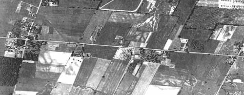
Neighbors like William Yeo, age 28, 70 acres, Warren Buckland, age 44, 35 acres, Parkhurst Corey, age 50, 26 acres; Peter N. Schenk, age 35, Patrick Blaker, 112 acres, School House #3, Brick Structure, 1828, Amos B. Buckland, brick house, age 48, 185 acres; Leonard Buckland, brick house, age 41, 128 acres (Brickyard south of house); Harvey Little, age 77, 95 acres.
In this 1930 Aerial View of Buckland Farm, the Farm is located at the “U” shaped driveway south of Westfall Road, about picture center.
1999
The LAND called Buckland Farmstead: Aerial View from the west
The land called Buckland Farmstead is pictured by an aerial photographer. The exact date of the photograph is unknown but the sign in the “U” shaped driveway shows that the Town had purchased the property. (possible date 1999) The small wooden shed located between the barns and connected to the Gas Pump has been removed. The removal of the contaminated soil has yet to started. This picture is taken almost directly over the barns but slightly west, with Westfall Road to the left of the barns.

2003
The LAND called Buckland Farmstead:
Aerial View, from the east
The land called Buckland Farmstead is pictured by an aerial photographer about three years beyond the previous slide’s photo. Two former barns have been removed, the contaminated soil has been replaced, the ground was leveled and the large pile of glacial rocks found in the contaminated hole have been piled behind the farmhouse. The land west of the barns is shown in the grading process for the new playgrounds.

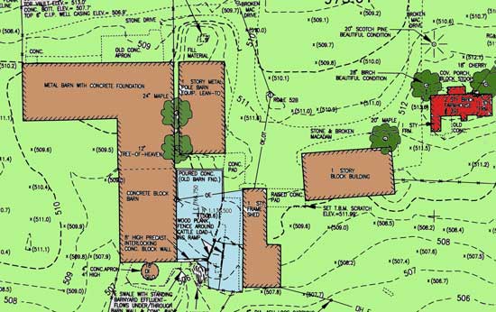
The Future
The LAND called Buckland Farmstead:
Historic Farmland of Brighton NY
The land called Buckland Farmstead was documented in this engineering drawing as the property was being studied for conversion to park land. The blue area represents an old barn foundation which may have belonged to the barns shown on the 1924 map below. The red colored building is the Buckland farmhouse, and the brown buildings are the barns, most of which were torn down in 2004.
Preservation
The preservation of the Buckland Farmstead property located on Westfall Road, purchased by the Town of Brighton, remains of great interest to the members of Historic Brighton. The simple design and utilitarian brick construction of the Buckland farmhouse exemplifies the settlement and growth of the community and depicts the two main occupations of nineteenth and early twentieth century Brighton, brick making and agriculture. Not a grand, high-style house, it is nonetheless worthy of preservation because it typifies the experience of the average Brighton citizen. The possible restoration of this property will allow access to a glimpse of Brighton farms past.

The drawing is from the 1924 Map of Monroe County. The Red building is the Buckland Farmstead, the yellow buildings are the barn structures which are in the approximate location as in the year 2000 aerial photo, but different in size, number and arrangement.
The economic factors in saving the house are not generous enough to allow the Buckland barns to be saved. The history of the development of barn structures on the Buckland property is not well recorded and now when all are gone, so is their history. The 1924 map segment shown here illustrates a barn layout that is different from the aerial photos taken in 2000 and engineering drawing of barns shown above. What were the structure, size, shape and use of the buildings may never be known. When was the first barn built and what type was it? We may never know.